Wondering how drone data adds value to the customer? Esri Switzerland and Wingtra join their forces to bring high quality information to the user.
Esri, famous for its ArcGIS platform and other geographical data software, used the high quality images from the surveying drone WingtraOne to gain critical data for construction and planning of a quarry in Switzerland. The Sony RX1R2, a 42 MP full-frame camera along with an ultra low distortion lens was used to capture the images. Such a camera setup ensures photos of an extremely high resolution, giving richer detail and increasing the accuracy of final maps or 3D models.
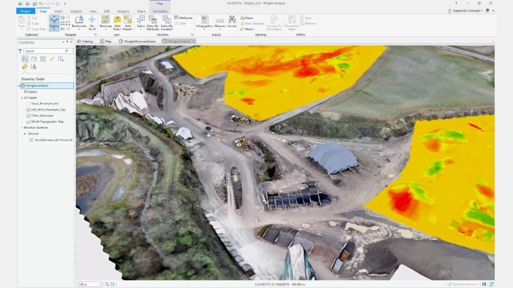
The Drone2Map tool processed the images after the WingtraOne flew over the specified route in the quarry. After that, a one click process within the ArcGIS platform generated products such as orthomosaics, elevation models, 3D point clouds and 3D textured meshes. From there, it is easy to create a ‘fly through’ animation to quickly give an overview of the land.
It’s a perfect match: WingtraOne collects high-resolution aerial images of the quarry that can be managed through the Esri’s ArcGIS platform.
The WingtraOne can map complicated and dangerous areas that would not be safe for humans to roam. With its vertical take-off and landing capabilities, it can take off anywhere without the need to hand-launch. It can bypass different terrain like rocky gravel and when landing, surveyors don’t need to worry about finding a soft place.
The 3D visual reconstruction tools on ArcGIS Pro can aid the quarry construction team in identifying potentially dangerous areas to work. A project manager can acknowledge risks of high elevation areas, keeping workers safe. ArcGIS can also indicate how much volume has been removed and added back to the quarry. With absolute accuracy down to 1 cm (0.4 in) with the WingtraOne, this is a highly precise measurement.

About Wingtra
Wingtra develops, produces and commercializes high precision VTOL drones that collect survey-grade aerial data. Wingtra entered the market in early 2017 and has been selling globally ever since. Recently the company has raised additional $5.8M to meet the demand in 2018 and partnered with biggest surveying, mining and precision agriculture equipment dealers across the globe. Find more information on wingtra.com
About Esri
Esri Switzerland combines data science with geography since 1993, with the wealth of experience of more than 40 employees at the headquarters in Zurich and the branch in Nyon. They are part of the worldwide GIS community supporting stakeholders with know-how and experience, and have more than one million users worldwide. The ArcGIS platform that Esri develops and continuously improves, brings together data from different sources, analyzes and visualizes them in the form of interactive and intuitive maps. Find out more on esri.ch


